


CHARLESTOWN A Voting District, Portage County, Ohio
About
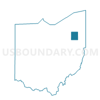
Outline

Summary
| Unique Area Identifier | 651068 |
| Name | CHARLESTOWN A Voting District |
| County | Portage County |
| State | Ohio |
| Area (square miles) | 21.95 |
| Land Area (square miles) | 19.37 |
| Water Area (square miles) | 2.58 |
| % of Land Area | 88.23 |
| % of Water Area | 11.77 |
| Latitude of the Internal Point | 41.16969240 |
| Longtitude of the Internal Point | -81.13816490 |
Maps


Graphs
Select a template below for downloading or customizing gragh for CHARLESTOWN A Voting District, Portage County, Ohio


Neighbors
Neighoring Voting District (by Name) Neighboring Voting District on the Map
- CHARLESTOWN B Voting District, Portage County, OH
- EDINBURG A Voting District, Portage County, OH
- EDINBURG B Voting District, Portage County, OH
- FREEDOM B Voting District, Portage County, OH
- PARIS A Voting District, Portage County, OH
- RAVENNA TWP F Voting District, Portage County, OH
- RAVENNA TWP G Voting District, Portage County, OH
- SHALERSVILLE D Voting District, Portage County, OH
- WINDHAM TWP B Voting District, Portage County, OH
Top 10 Neighboring County Subdivision (by Population) Neighboring County Subdivision on the Map
- Ravenna township, Portage County, OH (9,209)
- Rootstown township, Portage County, OH (8,225)
- Shalersville township, Portage County, OH (5,670)
- Palmyra township, Portage County, OH (2,919)
- Freedom township, Portage County, OH (2,843)
- Edinburg township, Portage County, OH (2,586)
- Windham township, Portage County, OH (1,865)
- Charlestown township, Portage County, OH (1,799)
- Paris township, Portage County, OH (1,744)
Top 10 Neighboring Unified School District (by Population) Neighboring Unified School District on the Map
- Ravenna City School District, OH (20,929)
- Crestwood Local School District, OH (14,788)
- Southeast Local School District, OH (11,574)
- James A. Garfield Local School District, OH (8,807)
- Rootstown Local School District, OH (8,306)
- School District Not Defined, OH (59)
Top 10 Neighboring State Legislative District Lower Chamber (by Population) Neighboring State Legislative District Lower Chamber on the Map
Top 10 Neighboring State Legislative District Upper Chamber (by Population) Neighboring State Legislative District Upper Chamber on the Map
Top 10 Neighboring 111th Congressional District (by Population) Neighboring 111th Congressional District on the Map
Top 10 Neighboring Census Tract (by Population) Neighboring Census Tract on the Map
- Census Tract 6005, Portage County, OH (5,670)
- Census Tract 6011, Portage County, OH (5,306)
- Census Tract 6006.03, Portage County, OH (4,074)
- Census Tract 6018.01, Portage County, OH (3,812)
- Census Tract 6007.06, Portage County, OH (2,919)
- Census Tract 6006.02, Portage County, OH (2,843)
- Census Tract 6007.05, Portage County, OH (2,586)
- Census Tract 6007.03, Portage County, OH (1,799)
- Census Tract 6007.04, Portage County, OH (1,744)